| Location |
| City: | | Alexandria, Louisiana, United States |
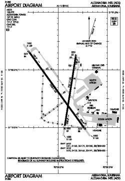
| Name: | Alexandria International Airport |
| ICAO / IATA: | KAEX / AEX |
| FAA: | AEX |
Details |
| Type: | Airport (Part 139 Class I) |
| Use: | Public/Civil |
| Latitude: | 31°19'39"N (31.327372) |
| Longitude: | 92°32'55"W (-92.548555) |
| Datum: | WGS 1984 |
| Elevation: | 88 ft (27 m) |
| Runways: | 2 |
| Longest: | 9352 × 150 ft (2850 × 45.5 m) |
Time |
| Timezone: | UTC+28:08 (DST+31:08) |
| Local Time: | |
Weather |
| METAR: | KAEX | 041408Z 16007KT 1/2SM FG VV002 17/16 A2994 RMK AO2 T01670161
|
| TAF: | KAEX | 041129Z 0412/0512 13004KT 2SM BR OVC004 TEMPO 0412/0415 1/2SM FG VV002
FM041500 16007KT 6SM BR VCSH OVC007
FM041800 20008KT P6SM VCSH OVC015
FM050200 16004KT P6SM OVC007
FM050600 17003KT 2SM BR OVC003
|
Related Locations |
| Nearby: | |
| Farthest: | CCK: 10986 mi / 17681 km
West Island (Pulau Panjang) [Cocos (Keeling) Islands], CC |
Find: |
|
Other Information |
Maps:
|
Delays:
|
Links:
|
Sources:
|
|