| Location |
| City: | | Pittsburgh, Pennsylvania, United States |
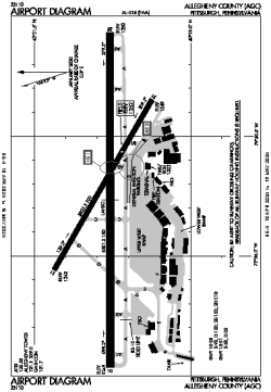
| Name: | Allegheny County Airport |
| ICAO / IATA: | KAGC / AGC |
| FAA: | AGC |
Details |
| Type: | Airport (Airfield) |
| Use: | Public/Civil |
| Latitude: | 40°21'16"N (40.354438) |
| Longitude: | 79°55'45"W (-79.929046) |
| Datum: | WGS 1984 |
| Elevation: | 1251 ft (381 m) |
| Runways: | 2 |
| Longest: | 6501 × 150 ft (1982 × 45.5 m) |
Time |
| Timezone: | UTC+29:08 (DST+32:08) |
| Local Time: | |
Weather |
| METAR: | KAGC | 041353Z 17009KT 4SM HZ CLR 06/02 A3002 RMK AO2 SLP177 T00560022
|
| TAF: | KAGC | 041134Z 0412/0512 19004KT P6SM SCT250
FM042300 18008KT P6SM BKN050
FM050200 21008KT 6SM -RA BKN025 WS020/22040KT
FM050700 21006KT 5SM -RA OVC010 WS020/24040KT
|
Related Locations |
| Nearby: | |
| Farthest: | YAUG: 11513 mi / 18529 km
Augusta [Augusta Airport], WA, AU |
Find: |
|
Other Information |
Maps:
|
Delays:
|
Links:
|
Sources:
|
|