| Location |
| City: | | Athens, Georgia, United States |
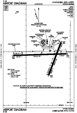
| Name: | Athens/Ben Epps Airport |
| ICAO / IATA: | KAHN / AHN |
| FAA: | AHN |
Details |
| Type: | Airport (Part 139 Class IV) |
| Use: | Public/Civil |
| Latitude: | 33°56'55"N (33.948640) |
| Longitude: | 83°19'33"W (-83.325913) |
| Datum: | WGS 1984 |
| Elevation: | 812 ft (247 m) |
| Runways: | 2 |
| Longest: | 6122 × 100 ft (1866 × 30.5 m) |
Time |
| Timezone: | UTC+29:08 (DST+32:08) |
| Local Time: | |
Weather |
| METAR: | KAHN | 041351Z 00000KT 8SM CLR 09/07 A3010 RMK AO2 SLP194 T00890067
|
| TAF: | KAHN | 041140Z 0412/0512 00000KT 5SM BR FEW250 TEMPO 0412/0414 3SM BR
FM041500 00000KT P6SM FEW015 SCT250
FM041700 24004KT P6SM SCT040 BKN120
FM050800 VRB03KT P6SM BKN025
FM051000 VRB03KT 6SM BR VCSH BKN009
|
Related Locations |
| Nearby: | |
| Farthest: | MQZ: 11387 mi / 18326 km
Margaret River [Margaret River Airport], WA, AU |
Find: |
|
Other Information |
Maps:
|
Delays:
|
Links:
|
Sources:
|
|