| Location |
| City: | | Walla Walla, Washington, United States |
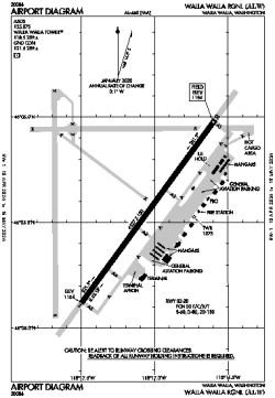
| Name: | Walla Walla Regional |
| ICAO / IATA: | KALW / ALW |
| FAA: | ALW |
Details |
| Type: | Airport (Part 139 Class I) |
| Use: | Public/Civil |
| Latitude: | 46°05'33"N (46.092542) |
| Longitude: | 118°17'03"W (-118.284081) |
| Datum: | WGS 1984 |
| Elevation: | 1194 ft (364 m) |
| Runways: | 1 |
| Longest: | 6527 × 150 ft (1989 × 45.5 m) |
Time |
| Timezone: | UTC+26:08 (DST+29:08) |
| Local Time: | |
Weather |
| METAR: | KALW | 041353Z AUTO 20010KT 10SM OVC002 M01/M03 A2942 RMK AO2 SLP970 T10111028
|
| TAF: | KALW | 041329Z 0413/0512 12005KT 4SM BR SCT002 TEMPO 0413/0416 2SM BR BKN002
FM041600 18006KT 6SM BR SCT002
FM042200 27009KT 1SM -SN BR OVC020
FM050000 02012KT 1/2SM SN FG VV003
FM050600 25005KT 4SM -SHSN BR OVC010
|
Related Locations |
| Nearby: | |
| Farthest: | FAME: 11304 mi / 18193 km
Marion Island, Prince Edward Islands, WC, ZA |
Find: |
|
Other Information |
Maps:
|
Delays:
|
Links:
|
Sources:
|
|