| Location |
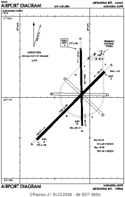
| City: | | Alexandria, Al Iskandariyah (Alexandria), Egypt |
| Name: | Alexandria International (El Nouzha Airport) |
| ICAO / IATA: | HEAX / ALY |
Details |
| Type: | Airport (Aerodrome, Airfield) |
| Use: | Public/Civil |
| Latitude: | 31°11'02"N (31.183903) |
| Longitude: | 29°56'56"E (29.948889) |
| Datum: | WGS 1984 |
| Elevation: | -6 ft (-1 m) |
| Runways: | 2 |
| Longest: | 7221 × 148 ft (2201 × 45 m) |
Time |
| Timezone: | UTC+2 (DST+5) |
| Local Time: | |
Weather |
| METAR: | HEAX | 041400Z 09005KT 6000 NSC 24/11 Q1013 NOSIG
|
| TAF: | HEAX | 041100Z 0412/0518 VRB03KT 6000 NSC TEMPO 0412/0414 4000 HZ BECMG 0415/0417 06010KT CAVOK
|
Related Locations |
| Nearby: | |
| Farthest: | RVV: 11908 mi / 19163 km
Raivavae, Tubuai Islands, Austral Islands, PF |
Find: |
|
Other Information |
Maps:
|
Sources:
|
|