| Location |
| City: | | Naples, Florida, United States |
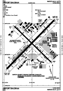
| Name: | Naples Municipal Airport |
| ICAO / IATA: | KAPF / APF |
| FAA: | APF |
Details |
| Type: | Airport (Part 139 Class I) |
| Use: | Public/Civil |
| Latitude: | 26°09'09"N (26.152441) |
| Longitude: | 81°46'32"W (-81.775638) |
| Datum: | WGS 1984 |
| Elevation: | 8 ft (2 m) |
| Runways: | 3 |
| Longest: | 6600 × 150 ft (2012 × 45.5 m) |
Time |
| Timezone: | UTC+29:08 (DST+32:08) |
| Local Time: | |
Weather |
| METAR: | KAPF | 041353Z 03005KT 10SM SCT011 21/18 A3006 RMK AO2 SLP176 T02060183
|
| TAF: | KAPF | 041123Z 0412/0512 VRB05KT P6SM SCT005 BKN035 TEMPO 0412/0414 SCT005 BKN015
FM041800 28008KT P6SM SCT020 BKN250
FM050000 VRB02KT P6SM FEW020 SCT250
|
Related Locations |
| Nearby: | |
| Farthest: | USL: 11505 mi / 18515 km
Useless Loop, WA, AU |
Find: |
|
Other Information |
Maps:
|
Delays:
|
Links:
|
Sources:
|
|