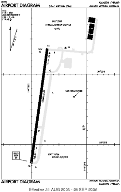
| Location |
| City: | | Lara, Victoria, Australia |
| Near (Alt.): | Geelong |
| Name: | Avalon Airport |
| ICAO / IATA: | YMAV / AVV |
Details |
| Type: | Airport (Aerodrome, Airfield) |
| Use: | Public/Civil |
| Latitude: | 38°02'22"S (-38.039443) |
| Longitude: | 144°28'10"E (144.469444) |
| Datum: | WGS 1984 |
| Elevation: | 35 ft (11 m) |
| Runways: | 1 |
| Longest: | 10000 × 148 ft (3048 × 45 m) |
Time |
| Timezone: | UTC+10 (DST+13) |
| Local Time: | |
Weather |
| METAR: | YMAV | 041400Z AUTO 18014KT 9999 // BKN024 OVC028 17/13 Q1018
|
| TAF: | YMAV | 040510Z 0406/0506 17015G25KT 9999 SCT030 BECMG 0409/0411 17010KT 9999 BKN020
FM042300 16012KT 9999 -SHRA FEW010 BKN018
FM050400 12015G25KT 9999 SCT030
|
Related Locations |
| Nearby: | |
| Farthest: | FLW: 12184 mi / 19608 km
Flores Island [Santa Cruz], 20, PT |
Find: |
|
Other Information |
Maps:
|
Links:
|
Sources:
|
|