world map with AYPY marked

AYPY - Airport

This information may not be accurate or current and is not valid for navigation or flight planning. No warranty of fitness for any purpose is made or implied.

flag of National Capital Districtflag of Papua-New Guinea

Donate via PayPal

Additional information is available on the NEW Great Circle Mapper

Location
City:  Port Moresby, National Capital District, Papua-New Guinea
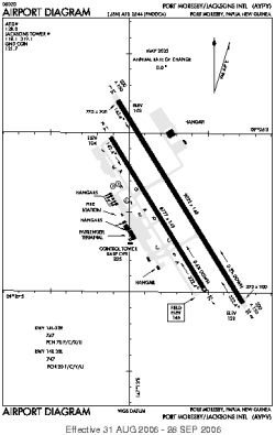
Name:Jacksons International Airport
ICAO / IATA:AYPY / POM

Details
Type:Airport (Aerodrome, Airfield)
Use:Public/Civil
Latitude:9°26'36"S (-9.443382)
Longitude:147°13'12"E (147.220050)
Datum:WGS 1984
Elevation:146 ft (45 m)
Runways:2
Longest:9022 × 148 ft (2750 × 45 m)

Time
Timezone:UTC+10 (DST+12)
Local Time:

Weather
METAR:AYPY  041400Z VRB03KT 9999 BKN110 27/25 Q1007=
TAF:AYPY  031335Z 0318/0418 34015KT 9999 SCT040
FM032100 34015G26KT 9999 SCT018 SCT140 T 25 25 31 33 Q 1005 1006 1008 1007

Related Locations
Nearby:
Farthest:BVR: 11783 mi / 18964 km
Esparadinha, Brava Island, CV

Find:

   beyond  
but within

Other Information
Maps:
Sources:


Airport Diagram

Airport diagram for AYPY

Airport diagram (OBSOLETE) from NGA


Great Circle Mapper   Great Circle Mapper
Great Circle Mapper FAQ   Great Circle Mapper FAQ
  Karl's Home Page
KLSē   KLSē Home
   GC on Facebook
Airlines of the World   Airlines of the World
Donate via PayPal


Copyright © 2004-2023, Karl L. Swartz. All rights reserved.
All trademarks mentioned herein belong to their respective owners.

Please see credits for attribution and copyright information.

Karl Swartz <karl@kls2.com>
  Powered by FreeBSD
Valid HTML 4.01!
Labeled with ICRA
hCard Microformat
Geo Microformat