| Location |
| City: | | Bermuda, Bermuda |
| Near (Alt.): | St. George |
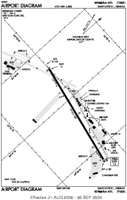
| Name: | L.F. Wade International (Bermuda International, Kindley Field) |
| ICAO / IATA: | TXKF / BDA |
Details |
| Type: | Airport (Aerodrome, Airfield) |
| Use: | Public/Civil |
| Latitude: | 32°21'51"N (32.364028) |
| Longitude: | 64°40'43"W (-64.678693) |
| Datum: | WGS 1984 |
| Elevation: | 18 ft (5 m) |
| Runways: | 1 |
| Longest: | 9706 × 150 ft (2958 × 45.5 m) |
Time |
| Timezone: | UTC+30:08 (DST+33:08) |
| Local Time: | |
Weather |
| METAR: | TXKF | 041355Z 12015KT 9999 SCT024 BKN170 OVC300 19/14 Q1021
|
| TAF: | TXKF | 041145Z 0412/0512 13015KT 9999 SCT025 OVC240 BECMG 0418/0421 15025KT 8000 -RA BKN015 TEMPO 0421/0506 3200 SHRA BKN012 PROB30 TEMPO 0421/0506 18030G40KT 1600 TSRA BKN009CB BECMG 0506/0509 20018KT 9999 VCSH BKN025
|
Related Locations |
| Nearby: | |
| Farthest: | YMUL: 12417 mi / 19984 km
Murray Field, WA, AU |
Find: |
|
Other Information |
Maps:
|
Links:
|
Sources:
|
|