| Location |
| City: | | Bridgeport, Connecticut, United States |
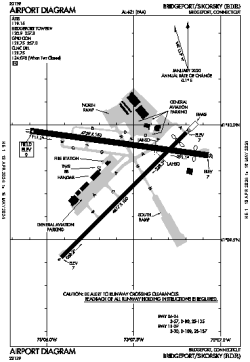
| Name: | Bridgeport/Sikorsky Airport |
| ICAO / IATA: | KBDR / BDR |
| FAA: | BDR |
Details |
| Type: | Airport (Part 139 Class IV) |
| Use: | Public/Civil |
| Latitude: | 41°09'49"N (41.163481) |
| Longitude: | 73°07'34"W (-73.126175) |
| Datum: | WGS 1984 |
| Elevation: | 8 ft (2 m) |
| Runways: | 2 |
| Longest: | 4759 × 150 ft (1451 × 45.5 m) |
Time |
| Timezone: | UTC+29:08 (DST+32:08) |
| Local Time: | |
Weather |
| METAR: | KBDR | 041352Z 00000KT 5SM HZ CLR 04/01 A3010 RMK AO2 SLP191 T00390011
|
| TAF: | KBDR | 041120Z 0412/0512 00000KT 3SM BR SCT002 TEMPO 0412/0414 2SM BR
FM041400 21005KT P6SM FEW250
FM042200 18004KT 6SM BR SCT250
FM050000 00000KT 3SM BR FEW020 BKN250
FM050500 00000KT 2SM BR BKN020
|
Related Locations |
| Nearby: | |
| Farthest: | YAUG: 11782 mi / 18962 km
Augusta [Augusta Airport], WA, AU |
Find: |
|
Other Information |
Maps:
|
Links:
|
Sources:
|
|