| Location |
| City: | | Binghamton, New York, United States |
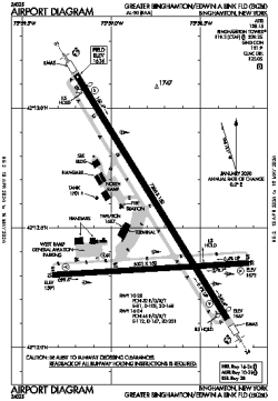
| Name: | Greater Binghamton/Edwin A Link Field |
| ICAO / IATA: | KBGM / BGM |
| FAA: | BGM |
Details |
| Type: | Airport (Part 139 Class I) |
| Use: | Public/Civil |
| Latitude: | 42°12'30"N (42.208444) |
| Longitude: | 75°58'47"W (-75.979610) |
| Datum: | WGS 1984 |
| Elevation: | 1635 ft (498 m) |
| Runways: | 2 |
| Longest: | 7305 × 150 ft (2227 × 45.5 m) |
Time |
| Timezone: | UTC+29:08 (DST+32:08) |
| Local Time: | |
Weather |
| METAR: | KBGM | 041353Z 22008KT 10SM SCT049 06/02 A3002 RMK AO2 SLP175 T00610017
|
| TAF: | KBGM | 041132Z 0412/0512 21006KT P6SM OVC050
FM041800 VRB04KT P6SM SCT080
FM050500 19010KT 6SM -SHRA OVC035
FM050900 22008KT P6SM OVC025
|
Related Locations |
| Nearby: | |
| Farthest: | YAUG: 11625 mi / 18708 km
Augusta [Augusta Airport], WA, AU |
Find: |
|
Other Information |
Maps:
|
Delays:
|
Links:
|
Sources:
|
|