| Location |
| City: | | Birmingham, Alabama, United States |
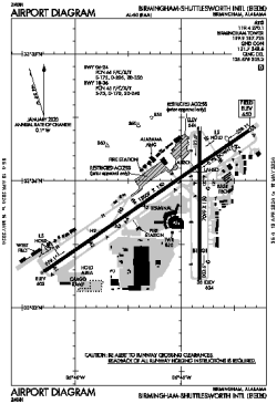
| Name: | Birmingham-Shuttlesworth International Airport |
| ICAO / IATA: | KBHM / BHM |
| FAA: | BHM |
Details |
| Type: | Airport (Part 139 Class I) |
| Use: | Public/Civil |
| Latitude: | 33°33'50"N (33.563889) |
| Longitude: | 86°45'08"W (-86.752305) |
| Datum: | WGS 1984 |
| Elevation: | 650 ft (198 m) |
| Runways: | 2 |
| Longest: | 12007 × 150 ft (3660 × 45.5 m) |
Time |
| Timezone: | UTC+28:08 (DST+31:08) |
| Local Time: | |
Weather |
| METAR: | KBHM | 041353Z 17003KT 4SM -RA BR OVC006 13/13 A3009 RMK AO2 RAB30 SLP188 P0000 T01330128
|
| TAF: | KBHM | 041128Z 0412/0512 VRB04KT P6SM SCT008 BKN030 TEMPO 0412/0416 6SM -RA BR BKN008 OVC012
FM041600 18007KT P6SM BKN015
FM050000 16004KT 6SM BR OVC012
FM050900 VRB02KT 4SM BR OVC007
|
Related Locations |
| Nearby: | |
| Farthest: | MQZ: 11188 mi / 18006 km
Margaret River [Margaret River Airport], WA, AU |
Find: |
|
Other Information |
Maps:
|
Delays:
|
Links:
|
Sources:
|
|