| Location |
| City: | | Birmingham, Warwickshire, England, United Kingdom |
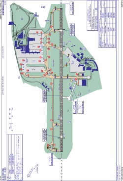
| Name: | Birmingham Airport (Birmingham International) |
| ICAO / IATA: | EGBB / BHX |
Details |
| Type: | Airport (Aerodrome, Airfield) |
| Use: | Public/Civil |
| Latitude: | 52°27'14"N (52.453856) |
| Longitude: | 1°44'53"W (-1.748027) |
| Elevation: | 341 ft (104 m) |
| Runways: | 1 |
| Longest: | 10013 × 148 ft (3052 × 45 m) |
Time |
| Timezone: | UTC+0 (DST+3) |
| Local Time: | |
Weather |
| METAR: | EGBB | 041350Z 33009KT 9999 FEW021 BKN030 10/05 Q1015
|
| TAF: | EGBB | 041100Z 0412/0512 21008KT 9999 SCT008 BKN020 BECMG 0412/0414 33010KT BECMG 0418/0421 VRB03KT PROB40 0421/0502 7000 PROB30 0502/0510 0300 FZFG BKN000 BECMG 0510/0512 17010KT 4000 BR BKN008
|
Related Locations |
| Nearby: | |
| Farthest: | NZDC: 11860 mi / 19087 km
Dunedin [City Heliport], OTA, NZ |
Find: |
|
Other Information |
Maps:
|
Links:
|
Sources:
|
|