| Location |
| City: | | Fort Bliss, Texas, United States |
| Near (Alt.): | El Paso |
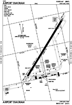
| Name: | Biggs AAF Airport (Fort Bliss) |
| ICAO / IATA: | KBIF / BIF |
| FAA: | BIF |
Details |
| Type: | Airport (Airfield) |
| Use: | Military |
| Latitude: | 31°50'58"N (31.849529) |
| Longitude: | 106°22'48"W (-106.380052) |
| Datum: | WGS 1984 |
| Elevation: | 3946 ft (1203 m) |
| Runways: | 1 |
| Longest: | 13554 × 150 ft (4131 × 45.5 m) |
Time |
| Timezone: | UTC+28:08 (DST+31:08) |
| Local Time: | |
Weather |
| METAR: | KBIF | 041358Z AUTO 00000KT 10SM BKN085 06/02 A2994 RMK AO2 SLP109 T00590018 $
|
| TAF: | KBIF | 041401Z 0414/0520 VRB06KT 9999 BKN070 QNH2991INS BECMG 0418/0419 25012G18KT 9999 SCT090 QNH2988INS TEMPO 0419/0502 24020G25KT BECMG 0503/0504 23009KT 9999 SCT100 QNH2990INS BECMG 0515/0516 23009KT 9999 SCT150 QNH2993INS TX22/0422Z TN06/0414Z
|
Related Locations |
| Nearby: | |
| Farthest: | RRG: 11388 mi / 18327 km
Plaine Corail [Sir Gaëtan Duval Airport (Plaine Corail Airport)], Rodrigues Island, MU |
Find: |
|
Other Information |
Maps:
|
Links:
|
Sources:
|
|