| Location |
| City: | | Bloomington/Normal, Illinois, United States |
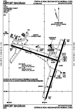
| Name: | Central IL Regional/Bloomington-Normal |
| ICAO / IATA: | KBMI / BMI |
| FAA: | BMI |
Details |
| Type: | Airport (Part 139 Class I) |
| Use: | Public/Civil |
| Latitude: | 40°28'38"N (40.477111) |
| Longitude: | 88°54'57"W (-88.915916) |
| Datum: | WGS 1984 |
| Elevation: | 871 ft (265 m) |
| Runways: | 2 |
| Longest: | 8000 × 150 ft (2438 × 45.5 m) |
Time |
| Timezone: | UTC+28:08 (DST+31:08) |
| Local Time: | |
Weather |
| METAR: | KBMI | 041409Z 18013KT 2 1/2SM BR BKN008 BKN036 OVC060 08/08 A2973 RMK AO2 CIG 004V010
|
| TAF: | KBMI | 041344Z 0414/0512 19014G20KT 6SM BR VCSH SCT010 OVC045 TEMPO 0414/0416 4SM BR BKN010 OVC035
FM041600 20014G20KT 2SM -SHRA BR OVC007
FM042100 29012KT P6SM OVC006
FM050000 31011KT P6SM SCT013
|
Related Locations |
| Nearby: | |
| Farthest: | YAUG: 11056 mi / 17793 km
Augusta [Augusta Airport], WA, AU |
Find: |
|
Other Information |
Maps:
|
Delays:
|
Links:
|
Sources:
|
|