| Location |
| City: | | Aguadilla, Puerto Rico, United States |
| Near (Alt.): | Borinquen |
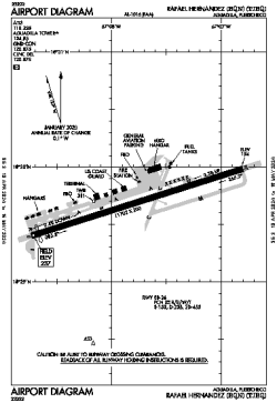
| Name: | Rafael Hernández Airport (USCG Air Station Borinquen) |
| ICAO / IATA: | TJBQ / BQN |
| FAA: | BQN |
Details |
| Type: | Airport (Part 139 Class I) |
| Use: | Public/Civil |
| Latitude: | 18°29'41"N (18.494861) |
| Longitude: | 67°07'46"W (-67.129443) |
| Datum: | WGS 1984 |
| Elevation: | 237 ft (72 m) |
| Runways: | 1 |
| Longest: | 11702 × 200 ft (3567 × 61 m) |
Time |
| Timezone: | UTC+30:08 (DST+32:08) |
| Local Time: | |
Weather |
| METAR: | TJBQ | 041350Z 08004KT 10SM CLR 26/21 A3005
|
| TAF: | TJBQ | 041141Z 0412/0512 10008KT P6SM SKC
FM041430 07012KT P6SM FEW025
FM041700 06015KT P6SM VCSH SCT022 BKN050
FM042300 09008KT P6SM VCSH SCT025 SCT070 AMD NOT SKED 0502/0511
|
Related Locations |
| Nearby: | |
| Farthest: | BWB: 12206 mi / 19644 km
Barrow Island, WA, AU |
Find: |
|
Other Information |
Maps:
|
Links:
|
Sources:
|
|