| Location |
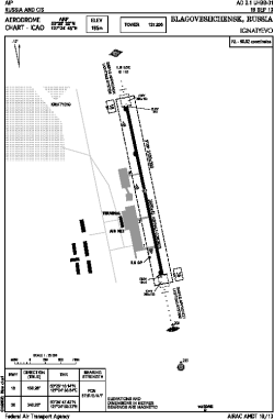
| City: | | Blagoveshchensk, Amurskaya, Russian Federation (Russia) |
| Name: | Ignatyevo Airport |
| ICAO / IATA: | UHBB / BQS |
Details |
| Type: | Airport (Aerodrome, Airfield) |
| Use: | Public/Civil |
| Latitude: | 50°25'32"N (50.425556) |
| Longitude: | 127°24'45"E (127.412500) |
| Elevation: | 640 ft (195 m) |
| Runways: | 1 |
| Longest: | 9186 × 148 ft (2800 × 45 m) |
Time |
| Timezone: | UTC+9 (DST+10) |
Weather |
| METAR: | UHBB | 041400Z 34002MPS CAVOK M30/M37 Q1015 R36/820250 NOSIG RMK QFE744/0992
|
| TAF: | UHBB | 041340Z 0415/0515 27003MPS CAVOK= TAF UHSS 041400Z 0415/0521 33010G15MPS 1400 SHSN BLSN BKN008 BKN023CB OVC100 TEMPO 0415/0501 0700 +SHSN BLSN BKN004 BKN017CB
FM050100 29006G11MPS 9999 BKN025CB TEMPO 0501/0509 1400 SHSN BLSN BKN007 BKN025CB BECMG 0509/0511 30003MPS TEMPO 0509/0521 1400 SHSN BKN006 BKN020CB
|
Related Locations |
| Nearby: | |
| Farthest: | PSY: 12195 mi / 19626 km
Stanley (Port Stanley) [Port Stanley], FK |
Find: |
|
Other Information |
Maps:
|
Sources:
|
|