| Location |
| City: | | Bristol, Somerset, England, United Kingdom |
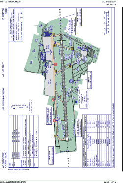
| Name: | Bristol International (Lulsgate) |
| ICAO / IATA: | EGGD / BRS |
Details |
| Type: | Airport (Aerodrome, Airfield) |
| Use: | Public/Civil |
| Latitude: | 51°22'58"N (51.382669) |
| Longitude: | 2°43'09"W (-2.719099) |
| Elevation: | 622 ft (190 m) |
| Runways: | 1 |
| Longest: | 6598 × 148 ft (2011 × 45 m) |
Time |
| Timezone: | UTC+0 (DST+3) |
| Local Time: | |
Weather |
| METAR: | EGGD | 041350Z 26010KT 9999 SCT012 08/08 Q1016
|
| TAF: | EGGD | 041103Z 0412/0512 28010KT 0200 FG BKN001 BECMG 0412/0415 9999 NSW FEW015 BECMG 0416/0419 VRB04KT BECMG 0423/0502 6000 PROB30 0502/0505 3000 BR MIFG BECMG 0505/0508 2000 BR -RADZ BKN002 PROB40 TEMPO 0505/0510 0300 FG DZ BKN001 BECMG 0510/0512 15010KT TEMPO 0510/0512 6000 NSW BKN005
|
Related Locations |
| Nearby: | |
| Farthest: | NZDC: 11943 mi / 19221 km
Dunedin [City Heliport], OTA, NZ |
Find: |
|
Other Information |
Maps:
|
Sources:
|
|