| Location |
| City: | | Baltimore, Maryland, United States |
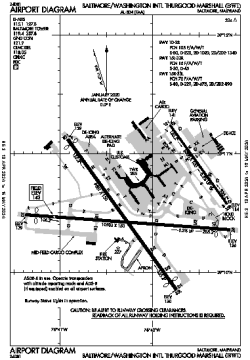
| Name: | Baltimore/Washington International Thurgood Marshall Airport |
| ICAO / IATA: | KBWI / BWI |
| FAA: | BWI |
Details |
| Type: | Airport (Part 139 Class I) |
| Use: | Public/Civil |
| Latitude: | 39°10'33"N (39.175728) |
| Longitude: | 76°40'08"W (-76.668990) |
| Datum: | WGS 1984 |
| Elevation: | 143 ft (44 m) |
| Runways: | 3 |
| Longest: | 10503 × 150 ft (3201 × 45.5 m) |
Time |
| Timezone: | UTC+29:08 (DST+32:08) |
| Local Time: | |
Weather |
| METAR: | KBWI | 041354Z 00000KT 3SM BR FEW004 SCT250 02/01 A3011 RMK AO2 SLP196 T00170006
|
| TAF: | KBWI | 041318Z 0413/0518 00000KT 3/4SM BR BKN004 BKN250
FM041430 VRB03KT 3SM BR BKN006
FM041600 14004KT P6SM SCT250
FM050000 VRB03KT P6SM SCT090
FM050600 VRB03KT P6SM BKN050 BKN130
FM051700 32005KT P6SM BKN050
|
Related Locations |
| Nearby: | |
| Farthest: | YAUG: 11705 mi / 18837 km
Augusta [Augusta Airport], WA, AU |
Find: |
|
Other Information |
Maps:
|
Delays:
|
Links:
|
Sources:
|
|