| Location |
| City: | | Bozeman, Montana, United States |
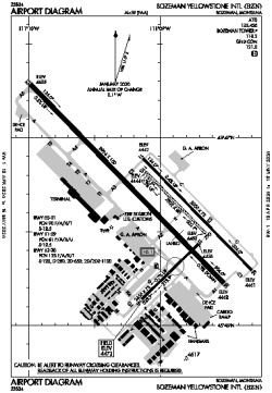
| Name: | Bozeman Yellowstone International Airport |
| ICAO / IATA: | KBZN / BZN |
| FAA: | BZN |
Details |
| Type: | Airport (Part 139 Class I) |
| Use: | Public/Civil |
| Latitude: | 45°46'38"N (45.777236) |
| Longitude: | 111°09'01"W (-111.150259) |
| Datum: | WGS 1984 |
| Elevation: | 4473 ft (1363 m) |
| Runways: | 4 |
| Longest: | 8994 × 150 ft (2741 × 45.5 m) |
Time |
| Timezone: | UTC+27:08 (DST+30:08) |
| Local Time: | |
Weather |
| METAR: | KBZN | 041356Z 32003KT 8SM OVC026 M21/M23 A2972 RMK AO2 SLP163 T12061228
|
| TAF: | KBZN | 041132Z 0412/0518 VRB05KT P6SM VCSH SCT025 BKN050 TEMPO 0412/0416 BKN025 OVC050
FM050800 VRB05KT 6SM -SHSN BKN035 OVC050
FM051500 27007KT 4SM -SN BR SCT015 OVC025
|
Related Locations |
| Nearby: | |
| Farthest: | FAME: 10964 mi / 17645 km
Marion Island, Prince Edward Islands, WC, ZA |
Find: |
|
Other Information |
Maps:
|
Delays:
|
Links:
|
Sources:
|
|