| Location |
| City: | | Springfield/Chicopee, Massachusetts, United States |
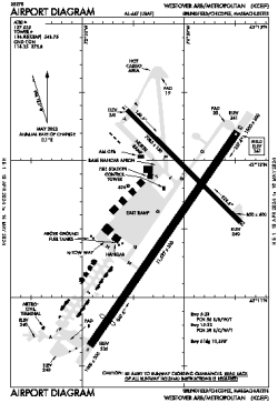
| Name: | Westover ARB/Metro Airport |
| ICAO / IATA: | KCEF / CEF |
| FAA: | CEF |
Details |
| Type: | Airport (Part 139 Class IV) |
| Use: | Public/Civil, Military |
| Latitude: | 42°11'38"N (42.194016) |
| Longitude: | 72°32'05"W (-72.534786) |
| Datum: | WGS 1984 |
| Elevation: | 241 ft (73 m) |
| Runways: | 2 |
| Longest: | 11597 × 300 ft (3535 × 91.5 m) |
Time |
| Timezone: | UTC+29:08 (DST+32:08) |
| Local Time: | |
Weather |
| METAR: | KCEF | 041356Z 00000KT 6SM BR SCT200 BNK250 02/00 A3006 RMK AO2A SLP188 T00180000
|
| TAF: | KCEF | 040300Z 0403/0509 20007KT 9000 BR SCT002 SCT250 QNH3002INS BECMG 0415/0416 22009KT 9999 NSW SCT050 BKN200 QNH3000INS BECMG 0501/0502 17006KT 9999 BKN050 BKN200 WS020/23030KT QNH2994INS BECMG 0506/0507 VRB03KT 3200 BR BKN002 BKN030 OVC200 WS015/23035KT QNH2992INS TX12/0420Z TN02/0403Z LAST NO AMDS AFT 0403 NEXT 0411
|
Related Locations |
| Nearby: | |
| Farthest: | YAUG: 11750 mi / 18910 km
Augusta [Augusta Airport], WA, AU |
Find: |
|
Other Information |
Maps:
|
Links:
|
Sources:
|
|