| Location |
| City: | | Cape Girardeau, Missouri, United States |
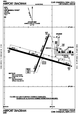
| Name: | Cape Girardeau Regional |
| ICAO / IATA: | KCGI / CGI |
| FAA: | CGI |
Details |
| Type: | Airport (Part 139 Class I) |
| Use: | Public/Civil |
| Latitude: | 37°13'31"N (37.225315) |
| Longitude: | 89°34'15"W (-89.570758) |
| Datum: | WGS 1984 |
| Elevation: | 341 ft (104 m) |
| Runways: | 2 |
| Longest: | 6500 × 150 ft (1981 × 45.5 m) |
Time |
| Timezone: | UTC+28:08 (DST+31:08) |
| Local Time: | |
Weather |
| METAR: | KCGI | 041353Z 19011KT 7SM OVC008 14/12 A2983 RMK AO2 SLP099 T01390122
|
| TAF: | KCGI | 041120Z 0412/0512 18014KT P6SM OVC018
FM041800 20012KT P6SM VCSH OVC008
FM042100 20011KT P6SM OVC010
FM050800 01010KT P6SM OVC008
|
Related Locations |
| Nearby: | |
| Farthest: | YAUG: 11044 mi / 17773 km
Augusta [Augusta Airport], WA, AU |
Find: |
|
Other Information |
Maps:
|
Links:
|
Sources:
|
|