| Location |
| City: | | Christchurch, Canterbury (Waitaha), New Zealand |
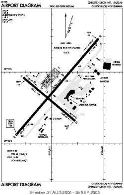
| Name: | Christchurch International Airport |
| ICAO / IATA: | NZCH / CHC |
Details |
| Type: | Airport (Aerodrome, Airfield) |
| Use: | Public/Civil |
| Latitude: | 43°29'22"S (-43.489443) |
| Longitude: | 172°32'04"E (172.534444) |
| Elevation: | 123 ft (37 m) |
| Runways: | 3 |
| Longest: | 10785 × 148 ft (3287 × 45 m) |
Time |
| Timezone: | UTC+12 (DST+15) |
| Local Time: | |
Weather |
| METAR: | NZCH | 041400Z AUTO 22012KT 9999 NCD 16/08 Q1010 NOSIG
|
| TAF: | NZCH | 041308Z 0412/0512 24012KT CAVOK BECMG 0416/0418 VRB02KT
FM050200 30015G25KT 9999 BKN050
FM051000 19015G25KT 9999 -RA BKN030
|
Related Locations |
| Nearby: | |
| Farthest: | LEVF: 12419 mi / 19986 km
Ribadeo [Villaframil], GA, ES |
Find: |
|
Other Information |
Maps:
|
Links:
|
Sources:
|
|