| Location |
| City: | | Cleveland, Ohio, United States |
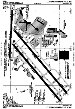
| Name: | Cleveland-Hopkins International Airport |
| ICAO / IATA: | KCLE / CLE |
| FAA: | CLE |
Details |
| Type: | Airport (Part 139 Class I) |
| Use: | Public/Civil |
| Latitude: | 41°24'34"N (41.409407) |
| Longitude: | 81°51'17"W (-81.854690) |
| Datum: | WGS 1984 |
| Elevation: | 799 ft (244 m) |
| Runways: | 3 |
| Longest: | 9953 × 150 ft (3034 × 45.5 m) |
Time |
| Timezone: | UTC+29:08 (DST+32:08) |
| Local Time: | |
Weather |
| METAR: | KCLE | 041351Z 18009KT 10SM FEW047 SCT250 10/04 A2996 RMK AO2 SLP148 T01000044
|
| TAF: | KCLE | 041124Z 0412/0518 18010KT P6SM FEW080 SCT250
FM042100 19015G25KT 3SM -SHRA BR OVC030
FM050300 22015G25KT 6SM -SHRA BR OVC008
FM050600 26009KT P6SM OVC008
FM050800 28010KT P6SM OVC030
|
Related Locations |
| Nearby: | |
| Farthest: | YAUG: 11392 mi / 18334 km
Augusta [Augusta Airport], WA, AU |
Find: |
|
Other Information |
Maps:
|
Delays:
|
Links:
|
Sources:
|
|