| Location |
| City: | | Hancock, Michigan, United States |
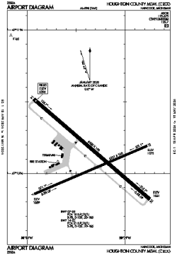
| Name: | Houghton County Memorial Airport |
| ICAO / IATA: | KCMX / CMX |
| FAA: | CMX |
Details |
| Type: | Airport (Part 139 Class I) |
| Use: | Public/Civil |
| Latitude: | 47°10'06"N (47.168416) |
| Longitude: | 88°29'21"W (-88.489068) |
| Datum: | WGS 1984 |
| Elevation: | 1095 ft (334 m) |
| Runways: | 2 |
| Longest: | 6500 × 150 ft (1981 × 45.5 m) |
Time |
| Timezone: | UTC+29:08 (DST+32:08) |
| Local Time: | |
Weather |
| METAR: | KCMX | 041353Z AUTO 06011KT 1 1/2SM -SN BR OVC007 M04/M07 A2967 RMK AO2 UPE51SNB09E18B33E42B51 SLP066 P0002 I1000 T10441067
|
| TAF: | KCMX | 041120Z 0412/0512 04011KT 2SM -PLSN BR OVC005 TEMPO 0412/0415 1 1/2SM -SN BR OVC003
FM041600 03013G23KT 3SM -SN OVC011
FM050000 35012G22KT 4SM -SHSN OVC015
FM050700 36009KT 3SM -SHSN OVC010
|
Related Locations |
| Nearby: | |
| Farthest: | YCSK: 10934 mi / 17596 km
Casey Station [Casey Station Skiway], Wilkes Land, AQ |
Find: |
|
Other Information |
Maps:
|
Links:
|
Sources:
|
|