| Location |
| City: | | Cocoa Beach, Florida, United States |
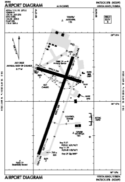
| Name: | Patrick Space Force Base Airport |
| ICAO / IATA: | KCOF / COF |
| FAA: | COF |
Details |
| Type: | Airport (Airfield) |
| Use: | Military |
| Latitude: | 28°14'06"N (28.235009) |
| Longitude: | 80°36'36"W (-80.609975) |
| Datum: | WGS 1984 |
| Elevation: | 7 ft (2 m) |
| Runways: | 2 |
| Longest: | 9008 × 200 ft (2746 × 61 m) |
Time |
| Timezone: | UTC+29:08 (DST+32:08) |
| Local Time: | |
Weather |
| METAR: | KCOF | 041356Z AUTO 31007KT 10SM FEW011 17/15 A3007 RMK AO2 SLP187 T01650154 $
|
| TAF: | KCOF | 031900Z 0319/0501 32006KT 9999 FEW015 SCT020 QNH2994INS BECMG 0401/0402 VRB05KT 9999 BKN020 QNH2998INS TEMPO 0401/0408 3600 BR BKN005 OVC010 BECMG 0409/0410 34008KT 4800 BR SCT005 BKN025 QNH2998INS BECMG 0415/0416 34008KT 9999 NSW SCT010 BKN030 QNH3000INS TX24/0321Z TN14/0412Z
|
Related Locations |
| Nearby: | |
| Farthest: | USL: 11572 mi / 18624 km
Useless Loop, WA, AU |
Find: |
|
Other Information |
Maps:
|
Links:
|
Sources:
|
|