| Location |
| City: | | Mosinee, Wisconsin, United States |
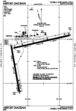
| Name: | Central Wisconsin Airport |
| ICAO / IATA: | KCWA / CWA |
| FAA: | CWA |
Details |
| Type: | Airport (Part 139 Class I) |
| Use: | Public/Civil |
| Latitude: | 44°46'40"N (44.777783) |
| Longitude: | 89°39'57"W (-89.665910) |
| Datum: | WGS 1984 |
| Elevation: | 1277 ft (389 m) |
| Runways: | 2 |
| Longest: | 7723 × 150 ft (2354 × 45.5 m) |
Time |
| Timezone: | UTC+28:08 (DST+31:08) |
| Local Time: | |
Weather |
| METAR: | KCWA | 041347Z 08007KT 3/4SM -RA BR OVC003 00/00 A2955 RMK VIS 1/2V1 1/4
|
| TAF: | KCWA | 041250Z 0413/0512 11010KT 1/4SM -FZRA FZFG OVC002 TEMPO 0413/0416 1 1/2SM -FZRA BR
FM041600 25006KT 2SM -RA OVC003
FM041800 29008KT 4SM -DZ OVC005
FM042000 30011G18KT P6SM OVC007
FM050100 32010G16KT P6SM BKN015
FM050400 34006KT P6SM SCT020
|
Related Locations |
| Nearby: | |
| Farthest: | YAUG: 10939 mi / 17604 km
Augusta [Augusta Airport], WA, AU |
Find: |
|
Other Information |
Maps:
|
Delays:
|
Links:
|
Sources:
|
|