| Location |
| City: | | Calgary, Alberta, Canada |
| Name: | Springbank Airport |
| ICAO: | CYBW |
Details |
| Type: | Airport (Airfield) |
| Use: | Public/Civil |
| Latitude: | 51°06'19"N (51.105278) |
| Longitude: | 114°22'17"W (-114.371388) |
| Elevation: | 3940 ft (1201 m) |
| Runways: | 2 |
| Longest: | 5000 ft (1524 m) |
Time |
| Timezone: | UTC+27:08 (DST+30:08) |
| Local Time: | |
Weather |
| METAR: | CYBW | 041421Z AUTO 10005KT 6SM HZ BKN014 BKN041 OVC080 M28/M32 A2990 RMK SLP264
|
| TAF: | CYBW | 041238Z 0413/0501 06005KT P6SM -SN FEW040 OVC100 TEMPO 0413/0422 5SM -SN BKN040 OVC100
FM042200 VRB03KT P6SM FEW120 RMK FCST BASED ON AUTO OBS. NXT FCST BY 041800Z
|
Related Locations |
| Nearby: | |
| Farthest: | FAME: 11150 mi / 17945 km
Marion Island, Prince Edward Islands, WC, ZA |
Find: |
|
Other Information |
Maps:
|
Links:
|
Sources:
|
|
|
|
Airport Diagram
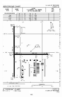
Airport diagram PDF from NAV Canada
|
