| Location |
| City: | | Gjoa Haven, Kitikmeot, Nunavut, Canada |
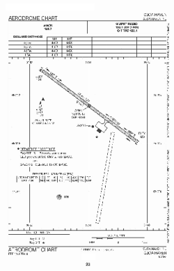
| Name: | Gjoa Haven Airport |
| ICAO / IATA: | CYHK / YHK |
Details |
| Type: | Airport (Airfield) |
| Use: | Public/Civil |
| Latitude: | 68°38'08"N (68.635556) |
| Longitude: | 95°51'01"W (-95.850277) |
| Elevation: | 154 ft (47 m) |
| Runways: | 1 |
| Longest: | 4400 ft (1341 m) |
Time |
| Timezone: | UTC+28:08 (DST+31:08) |
| Local Time: | |
Weather |
| METAR: | CYHK | 041400Z AUTO 01013G19KT 5SM HZ CLR M34/M37 A3015 RMK SLP222
|
| TAF: | CYHK | 041138Z 0412/0424 35020KT 1SM IC BLSN SKC TEMPO 0412/0418 3SM IC BLSN
FM041800 35015KT 6SM IC FEW015 SCT180 TEMPO 0418/0424 2SM IC BR RMK FCST BASED ON AUTO OBS. AUTO OBS NON-REPRESENTATIVE OF CRNT WX. NXT FCST BY 041800Z
|
Related Locations |
| Nearby: | |
| Farthest: | YCSK: 11713 mi / 18850 km
Casey Station [Casey Station Skiway], Wilkes Land, AQ |
Find: |
|
Other Information |
Maps:
|
Sources:
|
|