| Location |
| City: | | Mary's Harbour, Newfoundland and Labrador, Canada |
| ICAO / IATA: | CYMH / YMH |
Details |
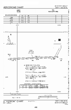
| Type: | Airport (Airfield) |
| Latitude: | 52°18'10"N (52.302833) |
| Longitude: | 55°50'50"W (-55.847166) |
| Elevation: | 34 ft (10 m) |
| Runways: | 1 |
| Longest: | 2500 × 75 ft (762 × 23 m) |
Time |
| Timezone: | UTC+30:38 (DST+33:38) |
| Local Time: | |
Weather |
| METAR: | CYMH | 041400Z AUTO 27006KT 9SM SCT110 SCT130 M12/M19 A2991 RMK SLP132
|
| TAF: | CYMH | 041341Z 0414/0502 23008KT P6SM SCT130 BKN160
FM041700 24008KT 6SM -SN SCT020 OVC050 TEMPO 0417/0422 21/2SM -SN BKN020 OVC050
FM042200 25006KT P6SM BKN050 RMK FCST BASED ON AUTO OBS. NXT FCST BY 042000Z
|
Related Locations |
| Nearby: | |
| Farthest: | YCSK: 11358 mi / 18279 km
Casey Station [Casey Station Skiway], Wilkes Land, AQ |
Find: |
|
Other Information |
Maps:
|
Sources:
|
|