| Location |
| City: | | Fort McMurray, Alberta, Canada |
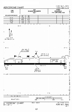
| Name: | Fort McMurray International Airport |
| ICAO / IATA: | CYMM / YMM |
Details |
| Type: | Airport (Airfield) |
| Use: | Public/Civil |
| Latitude: | 56°39'12"N (56.653333) |
| Longitude: | 111°13'24"W (-111.223332) |
| Elevation: | 1211 ft (369 m) |
| Runways: | 1 |
| Longest: | 7503 ft (2287 m) |
Time |
| Timezone: | UTC+27:08 (DST+30:08) |
| Local Time: | |
Weather |
| METAR: | CYMM | 041417Z AUTO 09003KT 1 3/4SM HZ FEW002 M40/M44 A3040 RMK SLP361
|
| TAF: | CYMM | 041238Z 0413/0501 VRB03KT 11/2SM IC BR BKN015 TEMPO 0413/0415 6SM IC BR FEW015 SCT230
FM041500 12005KT P6SM SKC TEMPO 0415/0501 5SM IC BR PROB40 0415/0419 11/2SM IC BR RMK FCST BASED ON AUTO OBS. NXT FCST BY 041900Z
|
Related Locations |
| Nearby: | |
| Farthest: | FAME: 10965 mi / 17646 km
Marion Island, Prince Edward Islands, WC, ZA |
Find: |
|
Other Information |
Maps:
|
Sources:
|
|