| Location |
| City: | | Gore Bay, Ontario, Canada |
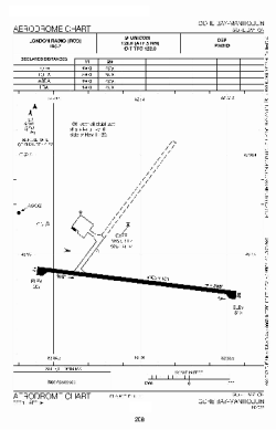
| Name: | Gore Bay-Manitoulin Airport |
| ICAO / IATA: | CYZE / YZE |
Details |
| Type: | Airport (Airfield) |
| Use: | Public/Civil |
| Latitude: | 45°53'03"N (45.884167) |
| Longitude: | 82°34'06"W (-82.568332) |
| Elevation: | 623 ft (190 m) |
| Runways: | 2 |
| Longest: | 5500 ft (1676 m) |
Time |
| Timezone: | UTC+29:08 (DST+32:08) |
| Local Time: | |
Weather |
| METAR: | CYZE | 041400Z AUTO 08013KT 9SM OVC007 M03/M04 A2982 RMK SLP112
|
| TAF: | CYZE | 041338Z 0414/0423 08010KT 3SM -FZDZ -SN BR BKN005 OVC012 TEMPO 0414/0416 P6SM NSW SCT005 OVC012
FM041600 09012G22KT 3SM -FZRA BR BKN005 OVC010
FM042100 13010G20KT 5SM -RA BR SCT008 OVC015 BECMG 0421/0423 20010G20KT RMK FCST BASED ON AUTO OBS. NXT FCST BY 042000Z
|
Related Locations |
| Nearby: | |
| Farthest: | YAUG: 11210 mi / 18041 km
Augusta [Augusta Airport], WA, AU |
Find: |
|
Other Information |
Maps:
|
Sources:
|
|