| Location |
| City: | | Sept-Îles, Québec, Canada |
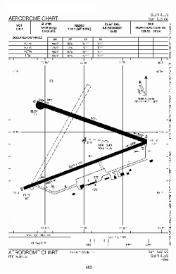
| Name: | Sept-Îles Airport |
| ICAO / IATA: | CYZV / YZV |
Details |
| Type: | Airport (Airfield) |
| Use: | Public/Civil |
| Latitude: | 50°13'24"N (50.223333) |
| Longitude: | 66°15'56"W (-66.265555) |
| Elevation: | 180 ft (55 m) |
| Runways: | 2 |
| Longest: | 6552 ft (1997 m) |
Time |
| Timezone: | UTC+29:08 (DST+32:08) |
| Local Time: | |
Weather |
| METAR: | CYZV | 041408Z 03005KT 3SM -SN VV020 M11/M13 A2987 RMK SN8 VIS VRB 2-4 SLP122
|
| TAF: | CYZV | 041139Z 0412/0512 04005KT 6SM -SN SCT015 OVC030 TEMPO 0412/0415 2SM -SN OVC015
FM041500 32005KT P6SM SCT020 BKN030
FM041800 30008KT P6SM FEW020 SCT030
FM050000 32005KT P6SM SCT160
FM050600 03005KT P6SM BKN080
FM050800 04008KT 2SM -SN BKN020 OVC040
FM051000 06008KT 3/4SM -SN VV008 BECMG 0510/0512 08015G25KT RMK NXT FCST BY 041800Z
|
Related Locations |
| Nearby: | |
| Farthest: | YDEK: 11360 mi / 18281 km
Denmark, WA, AU |
Find: |
|
Other Information |
Maps:
|
Sources:
|
|