| Location |
| City: | | Daytona Beach, Florida, United States |
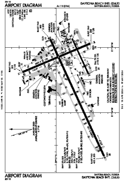
| Name: | Daytona Beach International Airport |
| ICAO / IATA: | KDAB / DAB |
| FAA: | DAB |
Details |
| Type: | Airport (Part 139 Class I) |
| Use: | Public/Civil |
| Latitude: | 29°10'48"N (29.179909) |
| Longitude: | 81°03'29"W (-81.058041) |
| Datum: | WGS 1984 |
| Elevation: | 34 ft (10 m) |
| Runways: | 3 |
| Longest: | 10500 × 150 ft (3200 × 45.5 m) |
Time |
| Timezone: | UTC+29:08 (DST+32:08) |
| Local Time: | |
Weather |
| METAR: | KDAB | 041353Z 36004KT 10SM OVC011 14/13 A3009 RMK AO2 SLP190 T01440133
|
| TAF: | KDAB | 041120Z 0412/0512 36007KT P6SM OVC009
FM041500 03006KT P6SM SCT010 BKN025
FM041800 04008KT P6SM SCT025 SCT180
FM050000 VRB03KT P6SM SCT150 SCT250
|
Related Locations |
| Nearby: | |
| Farthest: | USL: 11536 mi / 18565 km
Useless Loop, WA, AU |
Find: |
|
Other Information |
Maps:
|
Delays:
|
Links:
|
Sources:
|
|