| Location |
| City: | | Dayton, Ohio, United States |
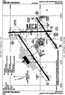
| Name: | James M Cox Dayton International Airport |
| ICAO / IATA: | KDAY / DAY |
| FAA: | DAY |
Details |
| Type: | Airport (Part 139 Class I) |
| Use: | Public/Civil |
| Latitude: | 39°54'08"N (39.902252) |
| Longitude: | 84°13'10"W (-84.219411) |
| Datum: | WGS 1984 |
| Elevation: | 1009 ft (308 m) |
| Runways: | 3 |
| Longest: | 10901 × 150 ft (3323 × 45.5 m) |
Time |
| Timezone: | UTC+29:08 (DST+32:08) |
| Local Time: | |
Weather |
| METAR: | KDAY | 041356Z 18011KT 10SM FEW080 SCT250 09/07 A2993 RMK AO2 SLP135 T00940067
|
| TAF: | KDAY | 041145Z 0412/0512 18012KT P6SM SCT250
FM041600 18012G20KT P6SM BKN080 OVC120
FM041900 19012G20KT P6SM -RA BKN018 OVC070 TEMPO 0421/0423 5SM -RA
FM042300 20012KT 5SM -RA OVC012
FM050500 26009KT 5SM -RA BR OVC005
FM050800 31007KT P6SM OVC012
|
Related Locations |
| Nearby: | |
| Farthest: | YAUG: 11307 mi / 18197 km
Augusta [Augusta Airport], WA, AU |
Find: |
|
Other Information |
Maps:
|
Delays:
|
Links:
|
Sources:
|
|