| Location |
| City: | | Washington, District of Columbia, United States |
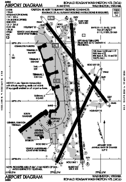
| Name: | Ronald Reagan Washington National Airport |
| ICAO / IATA: | KDCA / DCA |
| FAA: | DCA |
Details |
| Type: | Airport (Part 139 Class I) |
| Use: | Public/Civil |
| Latitude: | 38°51'05"N (38.851440) |
| Longitude: | 77°02'16"W (-77.037720) |
| Datum: | WGS 1984 |
| Elevation: | 14 ft (4 m) |
| Runways: | 3 |
| Longest: | 7169 × 150 ft (2185 × 45.5 m) |
Time |
| Timezone: | UTC+29:08 (DST+32:08) |
| Local Time: | |
Weather |
| METAR: | KDCA | 041352Z 04004KT 5SM HZ FEW250 03/00 A3012 RMK AO2 SLP199 T00330000
|
| TAF: | KDCA | 041126Z 0412/0518 VRB03KT P6SM SCT250
FM041800 17005KT P6SM SCT200
FM050000 VRB03KT P6SM SCT200
FM050500 VRB03KT P6SM BKN050 BKN130
FM051700 32005KT P6SM BKN050
|
Related Locations |
| Nearby: | |
| Farthest: | YAUG: 11695 mi / 18822 km
Augusta [Augusta Airport], WA, AU |
Find: |
|
Other Information |
Maps:
|
Delays:
|
Links:
|
Sources:
|
|