| Location |
| City: | | Elizabeth City, North Carolina, United States |
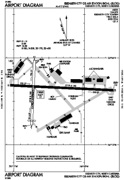
| Name: | Elizabeth City Coast Guard Air Station/Regional |
| ICAO / IATA: | KECG / ECG |
| FAA: | ECG |
Details |
| Type: | Airport (Airfield) |
| Use: | Public/Civil |
| Latitude: | 36°15'38"N (36.260576) |
| Longitude: | 76°10'28"W (-76.174566) |
| Datum: | WGS 1984 |
| Elevation: | 10 ft (3 m) |
| Runways: | 2 |
| Longest: | 7219 × 150 ft (2200 × 45.5 m) |
Time |
| Timezone: | UTC+29:08 (DST+32:08) |
| Local Time: | |
Weather |
| METAR: | KECG | 041354Z 03017G23KT 10SM FEW050 BKN060 OVC075 12/06 A3001 RMK AO2 SLP162 T01170056
|
| TAF: | KECG | 041403Z 0414/0512 03015G25KT P6SM VCSH BKN050 OVC080
FM041800 01012KT P6SM OVC050
FM042300 36008KT P6SM BKN090
FM050500 33004KT P6SM SCT150
FM051000 29004KT P6SM SCT250
|
Related Locations |
| Nearby: | |
| Farthest: | YAUG: 11789 mi / 18973 km
Augusta [Augusta Airport], WA, AU |
Find: |
|
Other Information |
Maps:
|
Links:
|
Sources:
|
|