| Location |
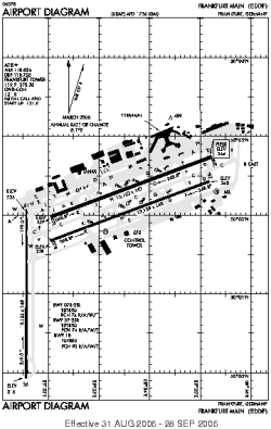
| City: | | Frankfurt, Hessen, Germany |
| Name: | Rhein-Main |
| ICAO / IATA: | EDDF / FRA |
Details |
| Type: | Airport (Flugplatz, Airfield) |
| Use: | Public/Civil |
| Latitude: | 50°02'00"N (50.033306) |
| Longitude: | 8°34'14"E (8.570456) |
| Elevation: | 364 ft (111 m) |
| Runways: | 4 |
| Longest: | 13123 × 197 ft (4000 × 60 m) |
Time |
| Timezone: | UTC+1 (DST+4) |
| Local Time: | |
Weather |
| METAR: | EDDF | 041350Z 19008KT 120V220 9999 FEW028 05/M03 Q1028 NOSIG
|
| TAF: | EDDF | 041100Z 0412/0518 18005KT CAVOK TEMPO 0504/0514 BKN030= TAF EDDH 041100Z 0412/0518 21015KT CAVOK TEMPO 0412/0424 21015G25KT TEMPO 0419/0504 4500 -RASN BKN014 PROB30 TEMPO 0419/0422 21020G30KT 2500 -SN BKN008 BECMG 0501/0503 24010KT BECMG 0504/0507 SCT008 BKN013 TEMPO 0504/0510 BKN008 PROB30 TEMPO 0504/0510 BKN004 BECMG 0510/0512 SCT012 BKN035
|
Related Locations |
| Nearby: | |
| Farthest: | CHT: 11941 mi / 19217 km
Waitangi [Tuuta], CIT, NZ |
Find: |
|
Other Information |
Maps:
|
Links:
|
Sources:
|
|