world map with EGUL marked

EGUL - Airport

This information may not be accurate or current and is not valid for navigation or flight planning. No warranty of fitness for any purpose is made or implied.

flag of Englandflag of United Kingdom

Donate via PayPal

Additional information is available on the NEW Great Circle Mapper

Location
City:  Lakenheath, Suffolk, England, United Kingdom
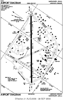
Name:RAF Lakenheath
ICAO / IATA:EGUL / LKZ

Details
Type:Airport (Aerodrome, Airfield)
Use:Military
Latitude:52°24'34"N (52.409333)
Longitude:0°33'40"E (0.561000)
Datum:WGS 1984
Elevation:32 ft (10 m)
Runways:1
Longest:9000 × 150 ft (2743 × 45.5 m)

Time
Timezone:UTC+0 (DST+3)
Local Time:

Weather
METAR:EGUL  041356Z AUTO 22011KT 9999 BKN007 OVC012 08/07 A2996 RMK AO2 DZE02RAB02E16DZB16E18RAB24E34DZB34E37RAB39E49DZB49E53 SLP149 P0000 T00830071 $
TAF:EGUL  (expired)

Related Locations
Nearby:
Farthest:CHT: 11821 mi / 19023 km
Waitangi [Tuuta], CIT, NZ

Find:

   beyond  
but within

Other Information
Maps:
Links:
Sources:


Airport Diagram

Airport diagram for EGUL

Airport diagram (OBSOLETE) from NGA


Great Circle Mapper   Great Circle Mapper
Great Circle Mapper FAQ   Great Circle Mapper FAQ
  Karl's Home Page
KLSē   KLSē Home
   GC on Facebook
Airlines of the World   Airlines of the World
Donate via PayPal


Copyright © 2004-2023, Karl L. Swartz. All rights reserved.
All trademarks mentioned herein belong to their respective owners.

Please see credits for attribution and copyright information.

Karl Swartz <karl@kls2.com>
  Powered by FreeBSD
Valid HTML 4.01!
Labeled with ICRA
hCard Microformat
Geo Microformat