| Location |
| City: | | Fairbanks, Alaska, United States |
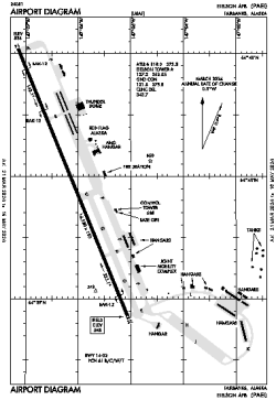
| Name: | Eielson AFB |
| ICAO / IATA: | PAEI / EIL |
| FAA: | EIL |
Details |
| Type: | Airport (Airfield) |
| Use: | Military |
| Latitude: | 64°39'56"N (64.665644) |
| Longitude: | 147°06'05"W (-147.101438) |
| Datum: | WGS 1984 |
| Elevation: | 547 ft (167 m) |
| Runways: | 1 |
| Longest: | 14530 × 150 ft (4429 × 45.5 m) |
Time |
| Timezone: | UTC+25:08 (DST+28:08) |
| Local Time: | |
Weather |
| METAR: | PAEI | 041411Z AUTO 21004KT 10SM OVC004 M12/M15 A3005 RMK AO2 SLP192 $
|
| TAF: | PAEI | 041200Z 0412/0518 VRB06KT 4800 -SN BKN006 OVC020 610066 QNH3000INS BECMG 0504/0506 09006KT 9999 NSW SCT006 BKN060 QNH2978INS BECMG 0517/0518 12005KT 4800 -SN SCT006 BKN010 OVC020 620109 QNH2974INS TXM08/0500Z TNM16/0512Z
|
Related Locations |
| Nearby: | |
| Farthest: | FAME: 11185 mi / 18001 km
Marion Island, Prince Edward Islands, WC, ZA |
Find: |
|
Other Information |
Maps:
|
Links:
|
Sources:
|
|