| Location |
| City: | | New Bern, North Carolina, United States |
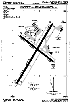
| Name: | Coastal Carolina Regional |
| ICAO / IATA: | KEWN / EWN |
| FAA: | EWN |
Details |
| Type: | Airport (Part 139 Class I) |
| Use: | Public/Civil |
| Latitude: | 35°04'22"N (35.072854) |
| Longitude: | 77°02'35"W (-77.043019) |
| Datum: | WGS 1984 |
| Elevation: | 17 ft (5 m) |
| Runways: | 2 |
| Longest: | 6452 × 150 ft (1967 × 45.5 m) |
Time |
| Timezone: | UTC+29:08 (DST+32:08) |
| Local Time: | |
Weather |
| METAR: | KEWN | 041354Z 35009KT 10SM -RA OVC060 10/08 A2999 RMK AO2 SLP155 P0000 T01000083
|
| TAF: | KEWN | 041123Z 0412/0512 35013G22KT P6SM -RA SCT025 OVC040
FM041500 36011G18KT P6SM VCSH SCT025 BKN035
FM041800 35010G16KT P6SM BKN060
FM042200 35007KT P6SM BKN080
FM050500 32003KT P6SM SCT200
|
Related Locations |
| Nearby: | |
| Farthest: | YAUG: 11748 mi / 18906 km
Augusta [Augusta Airport], WA, AU |
Find: |
|
Other Information |
Maps:
|
Links:
|
Sources:
|
|