| Location |
| City: | | Johannesburg, Gauteng, South Africa |
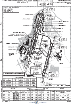
| Name: | O.R. Tambo International (Jan Smuts International) |
| ICAO / IATA: | FAOR / JNB |
Details |
| Type: | Airport (Aerodrome, Airfield) |
| Use: | Public/Civil |
| Latitude: | 26°08'01"S (-26.133693) |
| Longitude: | 28°14'32"E (28.242317) |
| Elevation: | 5558 ft (1694 m) |
| Runways: | 2 |
| Longest: | 14495 × 197 ft (4418 × 60 m) |
Time |
| Timezone: | UTC+2 (DST+4) |
| Local Time: | |
Weather |
| METAR: | FAOR | 041400Z 32011KT 280V340 9999 FEW035 23/14 Q1020 NOSIG
|
| TAF: | FAOR | 032200Z 0400/0506 04007KT 9999 SCT025 TX25/0412Z TN15/0403Z PROB40 TEMPO 0400/0402 4000 TSRA FEW030CB PROB30 TEMPO 0402/0405 5000 BR BKN010 BECMG 0407/0409 32012KT BECMG 0410/0412 CAVOK BECMG 0412/0414 SCT035 TEMPO 0414/0416 FEW035TCU BECMG 0416/0418 VRB03KT PROB30 TEMPO 0416/0421 4000 TSRA FEW030CB BECMG 0422/0424 08010KT CAVOK BECMG 0503/0505 SCT025 PROB30 TEMPO 0504/0506 5000 BR BKN015
|
Related Locations |
| Nearby: | |
| Farthest: | HNM: 11980 mi / 19280 km
Hana, Maui, HI, US |
Find: |
|
Other Information |
Maps:
|
Links:
|
Sources:
|
|