| Location |
| City: | | Fargo, North Dakota, United States |
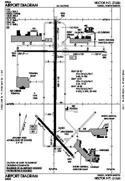
| Name: | Hector International Airport |
| ICAO / IATA: | KFAR / FAR |
| FAA: | FAR |
Details |
| Type: | Airport (Part 139 Class I) |
| Use: | Public/Civil |
| Latitude: | 46°55'14"N (46.920639) |
| Longitude: | 96°48'57"W (-96.815749) |
| Datum: | WGS 1984 |
| Elevation: | 901 ft (275 m) |
| Runways: | 3 |
| Longest: | 9001 × 150 ft (2744 × 45.5 m) |
Time |
| Timezone: | UTC+28:08 (DST+31:08) |
| Local Time: | |
Weather |
| METAR: | KFAR | 041353Z 33021G28KT 1 1/4SM UP BKN009 OVC046 M19/M22 A2998 RMK AO2 PK WND 33030/1324 UPE1256B05SNB1256E05 SLP179 P0000 T11941222
|
| TAF: | KFAR | 041135Z 0412/0512 34019G27KT 1SM -SN BLSN OVC010
FM041500 34019G27KT 1SM BLSN OVC015
FM042000 35017G25KT 3SM BLSN BKN035
FM050000 33010KT P6SM SCT040
|
Related Locations |
| Nearby: | |
| Farthest: | YCSK: 10757 mi / 17312 km
Casey Station [Casey Station Skiway], Wilkes Land, AQ |
Find: |
|
Other Information |
Maps:
|
Delays:
|
Links:
|
Sources:
|
|