| Location |
| City: | | Ascension Island, Ascension, St. Helena |
| Near (Alt.): | Georgetown |
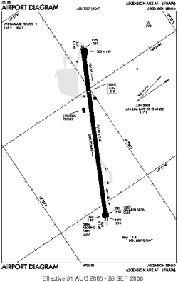
| Name: | RAF Ascension Island (Wideawake Field, Wide Awake Field) |
| ICAO / IATA: | FHAW / ASI |
Details |
| Type: | Airport (Aerodrome, Airfield) |
| Use: | Private |
| Latitude: | 7°58'11"S (-7.969596) |
| Longitude: | 14°23'37"W (-14.393663) |
| Datum: | WGS 1984 |
| Elevation: | 278 ft (85 m) |
| Runways: | 1 |
| Longest: | 10019 × 150 ft (3054 × 45.5 m) |
Time |
| Timezone: | UTC+0 (DST+2) |
| Local Time: | |
Weather |
| METAR: | FHAW | 040550Z 13012KT 9999 FEW020 25/21 Q1011 BLU NOSIG
|
| TAF: | FHAW | 040550Z 0406/0424 CNL
|
Related Locations |
| Nearby: | |
| Farthest: | UJE: 12363 mi / 19897 km
Ujae Atoll (Ujae Island), MH |
Find: |
|
Other Information |
Maps:
|
Links:
|
Sources:
|
|