| Location |
| City: | | Mauritius, Mauritius |
| Near (Alt.): | Plaine Magnien |
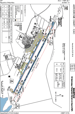
| Name: | Sir Seewoosagur Ramgoolam International (Plaisance Airport) |
| ICAO / IATA: | FIMP / MRU |
Details |
| Type: | Airport (Aerodrome, Airfield) |
| Use: | Public/Civil |
| Latitude: | 20°25'48"S (-20.429999) |
| Longitude: | 57°40'59"E (57.683056) |
| Elevation: | 183 ft (56 m) |
| Runways: | 1 |
| Longest: | 9974 × 148 ft (3040 × 45 m) |
Time |
| Timezone: | UTC+4 (DST+6) |
| Local Time: | |
Weather |
| METAR: | FIMP | 041400Z 11006KT 9999 VCSH FEW014TCU SCT014 BKN250 29/26 Q1012
|
| TAF: | FIMP | 041115Z 0412/0518 12008KT 9999 SCT014 TEMPO 0415/0506 7000 -SHRA FEW010 BKN014 BKN050 PROB30 TEMPO 0418/0502 4000 SHRA FEW006 FEW012CB BKN013 BKN045
|
Related Locations |
| Nearby: | |
| Farthest: | MMGD: 11789 mi / 18972 km
Guadalupe Island [Isla Guadalupe Airport], BCN, MX |
Find: |
|
Other Information |
Maps:
|
Links:
|
Sources:
|
|