| Location |
| City: | | Fort Lauderdale, Florida, United States |
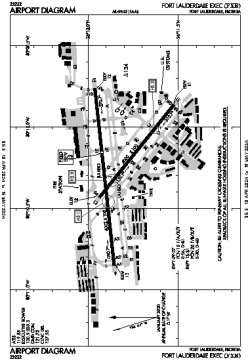
| Name: | Fort Lauderdale Exec Airport |
| ICAO / IATA: | KFXE / FXE |
| FAA: | FXE |
Details |
| Type: | Airport (Airfield) |
| Use: | Public/Civil |
| Latitude: | 26°11'50"N (26.197279) |
| Longitude: | 80°10'15"W (-80.170705) |
| Datum: | WGS 1984 |
| Elevation: | 13 ft (4 m) |
| Runways: | 2 |
| Longest: | 6002 × 100 ft (1829 × 30.5 m) |
Time |
| Timezone: | UTC+29:08 (DST+32:08) |
| Local Time: | |
Weather |
| METAR: | KFXE | 041353Z VRB04KT 10SM FEW008 SCT018 21/19 A3005 RMK AO2 SLP177 T02110194
|
| TAF: | KFXE | 041402Z 0414/0512 VRB05KT P6SM FEW010 BKN035
FM041800 04008KT P6SM SCT020 BKN250
FM050000 VRB02KT P6SM FEW020 SCT250
|
Related Locations |
| Nearby: | |
| Farthest: | USL: 11604 mi / 18675 km
Useless Loop, WA, AU |
Find: |
|
Other Information |
Maps:
|
Links:
|
Sources:
|
|