| Location |
| City: | | Green Bay, Wisconsin, United States |
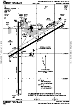
| Name: | Green Bay/Austin Straubel International Airport |
| ICAO / IATA: | KGRB / GRB |
| FAA: | GRB |
Details |
| Type: | Airport (Part 139 Class I) |
| Use: | Public/Civil |
| Latitude: | 44°29'05"N (44.484634) |
| Longitude: | 88°07'47"W (-88.129712) |
| Datum: | WGS 1984 |
| Elevation: | 695 ft (212 m) |
| Runways: | 2 |
| Longest: | 8700 × 150 ft (2652 × 45.5 m) |
Time |
| Timezone: | UTC+28:08 (DST+31:08) |
| Local Time: | |
Weather |
| METAR: | KGRB | 041353Z 00000KT M1/4SM FG VV002 02/01 A2959 RMK AO2 RAB18E30UPB30E42 SLP025 P0000 T00170011 RVRNO
|
| TAF: | KGRB | 041253Z 0413/0512 05007KT 1/4SM -RA FG OVC002 WS015/23040KT TEMPO 0413/0415 3/4SM -FZRA BR
FM041500 12006KT 1 1/2SM -RA BR OVC002 WS015/23040KT
FM041700 25009KT 3SM -RA BR OVC003
FM042000 27012G17KT 5SM -DZ OVC008
FM042200 28012G18KT P6SM BKN015
FM050000 32009G15KT P6SM SCT025
|
Related Locations |
| Nearby: | |
| Farthest: | YAUG: 11017 mi / 17730 km
Augusta [Augusta Airport], WA, AU |
Find: |
|
Other Information |
Maps:
|
Delays:
|
Links:
|
Sources:
|
|