| Location |
| City: | | Fort Lewis/Tacoma, Washington, United States |
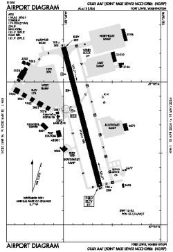
| Name: | Gray AAF Airport (Joint Base Lewis-McChord) |
| ICAO / IATA: | KGRF / GRF |
| FAA: | GRF |
Details |
| Type: | Airport (Airfield) |
| Use: | Military |
| Latitude: | 47°04'45"N (47.079219) |
| Longitude: | 122°34'51"W (-122.580782) |
| Datum: | WGS 1984 |
| Elevation: | 301 ft (92 m) |
| Runways: | 1 |
| Longest: | 6124 × 150 ft (1867 × 45.5 m) |
Time |
| Timezone: | UTC+26:08 (DST+29:08) |
| Local Time: | |
Weather |
| METAR: | KGRF | 041358Z 01017G20KT 10SM -SN OVC009 M02/M02 A2950 RMK AO2A SNE1259SNB45 SLP996 P0000 T10211021 $
|
| TAF: | KGRF | 041305Z 0413/0519 02012G18KT 4800 -SN BKN008 620089 QNH2947INS BECMG 0420/0421 03015G25KT 3200 BLSN BKN010 620109 510005 QNH2963INS BECMG 0500/0501 04012G18KT 9999 NSW FEW020 SCT090 QNH2969INS BECMG 0505/0506 05009KT 9999 FEW030 QNH2979INS TXM02/0421Z TNM07/0509Z
|
Related Locations |
| Nearby: | |
| Farthest: | FAME: 11517 mi / 18535 km
Marion Island, Prince Edward Islands, WC, ZA |
Find: |
|
Other Information |
Maps:
|
Links:
|
Sources:
|
|