| Location |
| City: | | Agana, Guam, United States |
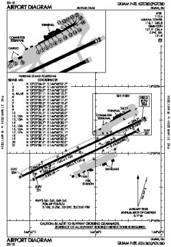
| Name: | Antonio B. Won Pat International (Guam International) |
| ICAO / IATA: | PGUM / GUM |
| FAA: | GUM |
Details |
| Type: | Airport (Part 139 Class I) |
| Use: | Public/Civil |
| Latitude: | 13°29'02"N (13.483952) |
| Longitude: | 144°47'50"E (144.797129) |
| Datum: | WGS 1984 |
| Elevation: | 305 ft (93 m) |
| Runways: | 2 |
| Longest: | 12014 × 150 ft (3662 × 45.5 m) |
Time |
| Timezone: | UTC+10 (DST+12) |
| Local Time: | |
Weather |
| METAR: | PGUM | 041401Z 05010KT 10SM FEW019 FEW027 25/24 A2997 RMK AO2 T02500239
|
| TAF: | PGUM | 041120Z 0412/0518 05011KT P6SM VCSH FEW015 SCT035 BKN050
FM041400 06011KT P6SM FEW025 SCT050
FM042300 05017G26KT P6SM SCT025 SCT050
|
Related Locations |
| Nearby: | |
| Farthest: | SWVE: 12252 mi / 19717 km
[Tree Bies Resort], 0, BR |
Find: |
|
Other Information |
Maps:
|
Links:
|
Sources:
|
|