| Location |
| City: | | Portland, Oregon, United States |
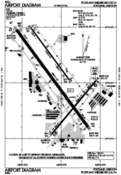
| Name: | Portland-Hillsboro Airport |
| ICAO / IATA: | KHIO / HIO |
| FAA: | HIO |
Details |
| Type: | Airport (Airfield) |
| Use: | Public/Civil |
| Latitude: | 45°32'32"N (45.542122) |
| Longitude: | 122°57'03"W (-122.950721) |
| Datum: | WGS 1984 |
| Elevation: | 207 ft (63 m) |
| Runways: | 3 |
| Longest: | 6600 × 150 ft (2012 × 45.5 m) |
Time |
| Timezone: | UTC+26:08 (DST+29:08) |
| Local Time: | |
Weather |
| METAR: | KHIO | 041353Z 11003KT 6SM BR BKN010 BKN023 OVC032 01/00 A2944 RMK AO2 RAB28E47UPB47E51 SLP970 P0000 T00110000
|
| TAF: | KHIO | 041139Z 0412/0512 15006KT P6SM -SHRASN FEW007 BKN015 OVC030 TEMPO 0412/0416 1SM -SHSN BKN007 OVC020
FM041600 13005KT P6SM -SHSN SCT015 BKN025 OVC035 TEMPO 0416/0420 3SM -SHSN BKN015 OVC025
FM050100 08007KT P6SM VCSH SCT020 BKN040
|
Related Locations |
| Nearby: | |
| Farthest: | FAME: 11517 mi / 18535 km
Marion Island, Prince Edward Islands, WC, ZA |
Find: |
|
Other Information |
Maps:
|
Links:
|
Sources:
|
|